Datei:Reymanns Special-Karte 19 Heilsberg Pr HOll.jpg
Zur Navigation springen
Zur Suche springen

Größe dieser Vorschau: 800 × 524 Pixel. Weitere Auflösungen: 320 × 210 Pixel • 2.534 × 1.660 Pixel.
Originaldatei (2.534 × 1.660 Pixel, Dateigröße: 3,08 MB, MIME-Typ: image/jpeg)
Beschreibung
| Description / Beschreibung |
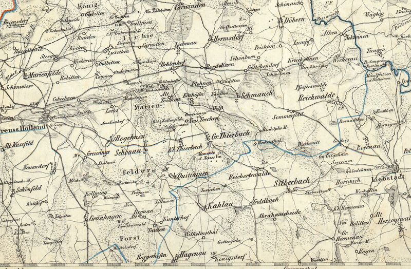
Ausschnitt Preußisch Hollannd aus der Reymanns Spezialkarte Nr.19 Heilsberg |
|---|---|
| Source / Quelle | |
| Scans / Scans | |
| Date / Datum |
um 1800 |
| Author / Urheber |
Reymann |
| Remarks / Anmerkungen |
Reymanns Spezialkarte Nr.19 Heilsberg |
| Permission / Genehmigung |
|
Lizenz
| The author of this image (scan or other media file) declares it public domain. The copyright of its original source (photography, book,...) has expired. This applies to the United States, Canada, the European Union and those countries with a copyright term of life of the author plus 70 years. |
Dateiversionen
Klicke auf einen Zeitpunkt, um diese Version zu laden.
| Version vom | Vorschaubild | Maße | Benutzer | Kommentar | |
|---|---|---|---|---|---|
| aktuell | 20:46, 22. Jan. 2014 | | 2.534 × 1.660 (3,08 MB) | Geraldraq (Diskussion • Beiträge) | ==Beschreibung== {{Information |Beschreibung =Ausschnitt Preußisch Hollannd aus der Reymanns Spezialkarte Nr.19 Heilsberg |Quelle = http://igrek.amzp.pl/1760803 |Urheber = Reymann |Datum = um 1800 |Scans =http://www.mapywig.org/m/German_maps/series/200K_ |
Du kannst diese Datei nicht überschreiben.
Dateiverwendung
Die folgenden 100 Seiten verwenden diese Datei:
- Alken (Landkreis Preußisch Holland)
- Alt Kußfeld
- Alt Teschen
- Amalienhof (Landkreis Preußisch Holland)
- Angnitten
- Behlenhof (Landkreis Preußisch Holland)
- Bernhardshof (Landkreis Preußisch Holland)
- Bordehnen
- Briensdorf
- Buchental (Juden)
- Bunden
- Döbern (Landkreis Preußisch Holland)
- Einhöfen
- Giebitten
- Gillgehnen (Landkreis Mohrungen)
- Golbitten (Landkreis Preußisch Holland)
- Greißings
- Grossainen
- Groß Quittainen
- Groß Thierbach (Landkreis Preußisch Holland)
- Grünhagen (Landkreis Preußisch Holland)
- Gudnick (Landkreis Mohrungen)
- Gut Davids
- Gut Gillgehnen
- Gut Guhren
- Göttchendorf
- Hartwich
- Hartwichs
- Hasselbusch (Landkreis Preußisch Holland)
- Hermsdorf (Landkreis Preußisch Holland)
- Kalthof (Landkreis Preußisch Holland)
- Kanditten (Landkreis Preußisch Holland)
- Kanthen
- Karwitten
- Kaymen (Landkreis Preußisch Holland)
- Klein Thierbach
- Klein Wickerau (Landkreis Preußisch Holland)
- Koken (Landkreis Preußisch Holland)
- Komthurhof
- Komthurwald
- Kopiehnen
- Koppeln
- Krickehnen
- Krönau (Landkreis Preußisch Holland)
- Köllming
- Liebenau (Landkreis Preußisch Holland)
- Lomp (Landkreis Preußisch Holland)
- Luxethen
- Lägs
- Marienfelde (Landkreis Preußisch Holland)
- Matzweißen
- Mäken (Landkreis Preußisch Holland)
- Mühle Behlenhof
- Nahmgeist
- Nauten
- Nektainen
- Neu Teschen
- Neuendorf (Landkreis Preußisch Holland)
- Peiskam (Landkreis Preußisch Holland)
- Pergusen
- Pfeiffertswalde
- Plehnen (Landkreis Preußisch Holland)
- Podangen
- Preußisch Holland
- Preußisch Holland/Reymann Karte 2
- Quittainen (Landkreis Preußisch Holland)
- Reichwalde (Landkreis Preußisch Holland)
- Robitten (Landkreis Preußisch Holland)
- Rogehnen (Landkreis Preußisch Holland)
- Rudolfsmühle (Landkreis Preußisch Holland)
- Schmauch
- Schodehnen
- Schwöllmen
- Schäferei (Weeskenhof)
- Schönau (Landkreis Preußisch Holland)
- Schönborn (Landkreis Preußisch Holland)
- Schönfeld (Landkreis Preußisch Holland)
- Schönwiese (Landkreis Preußisch Holland)
- Siebenhufen (Landkreis Preußisch Holland)
- Silberbach (Landkreis Mohrungen)
- Skollmen
- Solainen (Landkreis Preußisch Holland)
- Sommerfeld (Landkreis Preußisch Holland)
- Sorrehnen
- Steegen (Landkreis Preußisch Holland)
- Stobnitt
- Stöpen (Landkreis Preußisch Holland)
- Talpitten
- Taulen
- Teschenwalde (Landkreis Preußisch Holland)
- Tompitten
- Vogtshof
- Vorwerk Memento
- Vorwerk Peiskam
- Warnikam
- Weeskenitt
- Weinings
- Wickerau (Landkreis Preußisch Holland)
- Wirtshaus Vogelsang
- Zallenfelde